Atlas V N22 Starliner-1 — launch date, time, visibility & where to look
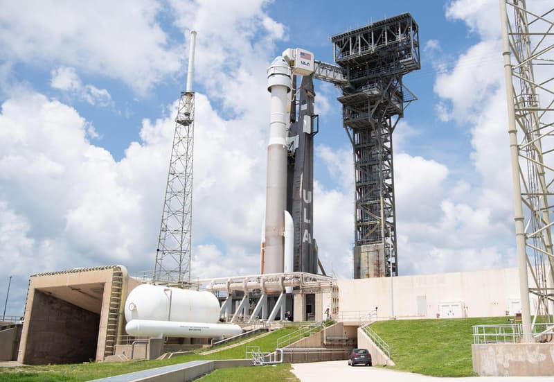
Starliner-1 is the first operational flight of a Starliner spacecraft to the International Space Station as part of NASA's Commercial Crew Program. Due to problems with the Starliner spacecraft's RCS attitude control system during the Crew Flight Test mission in 2024, this mission has been re-scoped to not carry a crew by NASA. It will instead deliver necessary cargo to the orbital laboratory and allow in-flight validation of the system upgrades implemented following the Crew Flight Test mission.
Countdown to liftoff
Targeting Thu, Jan 14, 2027 — the exact date and time are not set yet. Launch dates firm up close to the attempt; set a free alert below to get the final time.
Launch time
- Thu, Jan 14, 2027 — launch time not announced yet
This launch time is not yet confirmed. Rocket launches often slip by hours or days for weather, technical checks, or range scheduling; treat the time above as a target and re-check close to the date.
Free email alerts for Atlas V N22 | Starliner-1
A heads-up the day before, a reminder an hour out, Go-for-launch confirmation, and an email if the date moves.
Click the one confirmation email we send to activate. One-click unsubscribe.
Free email alert + a note if the date moves ✓ what you’re signing up for now
Pro a text when it’s a go and before liftoff (delivery times vary) · the weather at liftoff in the app · a minute-by-minute where-to-look plan · $19.99/yr or $4.99/mo
Free · no account needed
Sky outlook at the pad
Daily cloud cover and rain chance at Cape Canaveral SFS, FL, USA (liftoff is still beyond the 7-day forecast window):
Forecast at the launch site; check your own sky too: cloud over you can hide a launch the pad forecast says is clear.
Pro members get an hour-of-liftoff go/no-go call (cloud, wind, rain chance and visibility) in the launch finder. Pro · $19.99/yr
Visibility map: how far away can you see it?
The shaded zones show where Atlas V N22 is expected to be visible, following its modeled northeast flight path rather than a simple circle around the pad — a fair-or-better view reaches roughly 2000 miles out over land. Within about 89 miles the rocket clears the horizon in the first half-minute; by T+90s it is line-of-sight from roughly 305 miles. City dots are colored by the expected view quality; the table below has the direction to look from each.
Which cities can see this launch?
Estimated visibility from major towns near US launch sites, assuming clear skies and an open horizon. The 10 most likely first:
| City | Visibility | Look toward | Distance to pad |
|---|---|---|---|
| Port Canaveral, FL | Excellent | north | 12 mi |
| Titusville, FL | Excellent | east | 14 mi |
| Mims, FL | Excellent | east-southeast | 16 mi |
| Merritt Island, FL | Excellent | north-northeast | 17 mi |
| Cocoa Beach, FL | Excellent | north | 18 mi |
| Rockledge, FL | Excellent | north-northeast | 19 mi |
| Satellite Beach, FL | Excellent | north | 28 mi |
| Indialantic, FL | Excellent | north | 34 mi |
| Melbourne, FL | Excellent | north | 35 mi |
| New Smyrna Beach, FL | Excellent | southeast | 37 mi |
Show all 94 cities
| City | Visibility | Look toward | Distance to pad |
|---|---|---|---|
| Palm Bay, FL | Excellent | north | 38 mi |
| Sanford, FL | Excellent | east-southeast | 44 mi |
| Orlando, FL | Excellent | east | 48 mi |
| Daytona Beach, FL | Excellent | south-southeast | 51 mi |
| Sebastian, FL | Excellent | north | 53 mi |
| Kissimmee, FL | Excellent | east-northeast | 54 mi |
| Vero Beach, FL | Excellent | north | 66 mi |
| Palm Coast, FL | Excellent | south-southeast | 79 mi |
| Fort Pierce, FL | Excellent | north | 80 mi |
| Lakeland, FL | Good | east-northeast | 91 mi |
| Port St. Lucie, FL | Good | north | 92 mi |
| St. Augustine, FL | Good | south-southeast | 101 mi |
| Tampa, FL | Good | east-northeast | 122 mi |
| Gainesville, FL | Good | southeast | 128 mi |
| West Palm Beach, FL | Good | north-northwest | 133 mi |
| Jacksonville, FL | Good | south-southeast | 137 mi |
| Fort Lauderdale, FL | Good | north | 172 mi |
| Brunswick, GA | Good | south-southeast | 185 mi |
| Miami, FL | Good | north | 197 mi |
| Valdosta, GA | Fair | southeast | 224 mi |
| Savannah, GA | Good | south | 243 mi |
| Hilton Head Island, SC | Good | south | 251 mi |
| Tallahassee, FL | Fair | east-southeast | 257 mi |
| Charleston, SC | Good | south | 293 mi |
| Myrtle Beach, SC | Good | south-southwest | 367 mi |
| Pensacola Beach, FL | Marginal | east | 412 mi |
| Gulf Shores, AL | Marginal | east | 443 mi |
| Norfolk, VA | Fair | south-southwest | 623 mi |
| Virginia Beach, VA | Fair | south-southwest | 631 mi |
| Newport News, VA | Fair | south-southwest | 634 mi |
| Richmond, VA | Fair | south-southwest | 645 mi |
| Cape Charles, VA | Fair | south-southwest | 656 mi |
| Exmore, VA | Fair | south-southwest | 677 mi |
| Onancock, VA | Fair | south-southwest | 690 mi |
| Wallops Island, VA | Fair | south-southwest | 707 mi |
| Chincoteague, VA | Fair | south-southwest | 712 mi |
| Pocomoke City, MD | Fair | south-southwest | 716 mi |
| Salisbury, MD | Fair | south-southwest | 734 mi |
| Berlin, MD | Fair | south-southwest | 740 mi |
| Washington, DC | Marginal | south-southwest | 742 mi |
| Ocean City, MD | Fair | south-southwest | 745 mi |
| Annapolis, MD | Fair | south-southwest | 756 mi |
| Rehoboth Beach, DE | Fair | south-southwest | 768 mi |
| Baltimore, MD | Marginal | south-southwest | 774 mi |
| Cape May, NJ | Fair | south-southwest | 786 mi |
| Dover, DE | Fair | south-southwest | 786 mi |
| Ocean City, NJ | Fair | south-southwest | 815 mi |
| Philadelphia, PA | Fair | south-southwest | 844 mi |
| Grand Isle, LA | Not visible | — | 571 mi |
| Rockport, TX | Not visible | — | 1002 mi |
| Port Aransas, TX | Not visible | — | 1004 mi |
| Corpus Christi, TX | Not visible | — | 1025 mi |
| South Padre Island, TX | Not visible | — | 1032 mi |
| Port Isabel, TX | Not visible | — | 1034 mi |
| Laguna Vista, TX | Not visible | — | 1039 mi |
| Bayview, TX | Not visible | — | 1046 mi |
| Los Fresnos, TX | Not visible | — | 1051 mi |
| Brownsville, TX | Not visible | — | 1055 mi |
| Harlingen, TX | Not visible | — | 1062 mi |
| McAllen, TX | Not visible | — | 1094 mi |
| Laredo, TX | Not visible | — | 1155 mi |
| San Diego, CA | Not visible | — | 2182 mi |
| Pasadena, CA | Not visible | — | 2236 mi |
| Mojave, CA | Not visible | — | 2238 mi |
| Long Beach, CA | Not visible | — | 2239 mi |
| Los Angeles, CA | Not visible | — | 2242 mi |
| Malibu, CA | Not visible | — | 2268 mi |
| Thousand Oaks, CA | Not visible | — | 2276 mi |
| Bakersfield, CA | Not visible | — | 2286 mi |
| Oxnard, CA | Not visible | — | 2295 mi |
| Ventura, CA | Not visible | — | 2302 mi |
| Santa Barbara, CA | Not visible | — | 2325 mi |
| Fresno, CA | Not visible | — | 2331 mi |
| Solvang, CA | Not visible | — | 2350 mi |
| Buellton, CA | Not visible | — | 2353 mi |
| Los Alamos, CA | Not visible | — | 2357 mi |
| Santa Maria, CA | Not visible | — | 2366 mi |
| Orcutt, CA | Not visible | — | 2367 mi |
| Lompoc, CA | Not visible | — | 2368 mi |
| Vandenberg Village, CA | Not visible | — | 2368 mi |
| Guadalupe, CA | Not visible | — | 2374 mi |
| Pismo Beach, CA | Not visible | — | 2378 mi |
| San Luis Obispo, CA | Not visible | — | 2379 mi |
| San Jose, CA | Not visible | — | 2449 mi |
Where to look
A rocket lifts off below the horizon for distant viewers, then climbs into view as it gains altitude and flies downrange. Closer to the pad you'll see it within seconds; a few hundred miles away it can take three to six minutes to rise over the horizon. Find an open view in the direction shown for your city and start watching at liftoff.
More from United Launch Alliance ↗
Before you go
- Launch times change: scrubs and delays are common. Re-check the day of.
- Clear skies matter. Low cloud near the pad or along the trajectory can hide the rocket.
- Twilight launches are the most dramatic; daytime launches are the hardest to see at distance.
- Trajectory and timing here are estimates from a representative ascent profile.
Atlas V N22 Starliner-1 launch FAQ
When is the Atlas V N22 Starliner-1 launch date and time?
Atlas V N22 Starliner-1 is currently targeting Thu, Jan 14, 2027 — the launch time has not been announced yet. Status: To Be Determined. Launch dates slip often; the countdown on this page tracks the latest target, or set a free alert to get the final time.
Where does Atlas V N22 Starliner-1 launch from?
From Cape Canaveral SFS, FL, USA, operated by United Launch Alliance. If you are within a few hundred miles, the city-by-city table on this page shows the expected view from your area and which direction to look.
How far away can you see the Atlas V N22 Starliner-1 launch?
Roughly 305 miles with clear skies: within about 89 miles of the pad the rocket clears the horizon in the first half-minute, and by T+90 seconds it is high enough to be line-of-sight visible around 305 miles away. Night launches can be visible even farther as the exhaust plume catches sunlight. The viewing map on this page shows the expected zones along the flight path and which cities fall inside them.
More upcoming launches
- Vulcan | NROL-100 · 2026 · time TBD
- Vulcan | NROL-109 · 2026 · time TBD
- Vulcan | NROL-56 · 2026 · time TBD
- Vulcan | NROL-64 · 2026 · time TBD
- Vulcan | NROL-73 · 2026 · time TBD
- Vulcan | NROL-83 · 2026 · time TBD
- Vulcan | SDA Tranche 1 Tracking Layer B · 2026 · time TBD
- Vulcan | SDA Tranche 1 Tracking Layer E · 2026 · time TBD
Explore more
Launch data from TheSpaceDevs Launch Library 2. Page generated November 22, 2026.