Starship | Flight 13 — what you saw in the sky & launch recap
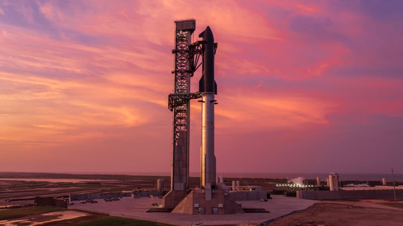
13th test flight of the two-stage Starship launch vehicle. Second flight of Starship V3. For the first time, Starship will carry 20 V3 Starlink satellites to space, which will extend solar arrays and antennas and will attempt to connect with ground stations in South Africa and the larger Starlink constellation via high-capacity lasers. 6 of the satellites have been modified with a suite of cameras to scan Starship’s heat shield and transmit imagery down to operators to continue testing methods of analyzing Starship’s heat shield readiness for return to launch site on future missions. Several tiles on Starship have been painted white to simulate missing tiles and serve as imaging targets in the test.
Missed this one? Get alerted for the next launch you can see
Enter your ZIP or city and we’ll email you about a day before every launch that clears your horizon, with the direction to look.
Click the one confirmation email we send to activate. One-click unsubscribe.
For free area alerts, we store your email, chosen location, alert preferences and delivery history so we can send and manage your alerts. Privacy details.
Free email alert + a note if the date moves ✓ what you’re signing up for now
Pro a text when it’s a go and before liftoff (delivery times vary) · the weather at liftoff in the app · a minute-by-minute where-to-look plan · $19.99/yr or $4.99/mo
Caught this one in person? Sign up free and start your launch log and mark this one as seen →
Free · no account needed
Liftoff time
- Jul 24, 2026, 10:51 PM UTC
- Jul 24, 2026, 6:51 PM Eastern
- Jul 24, 2026, 3:51 PM Pacific
What you saw
If you spotted a bright streak or contrail in the sky from Port Isabel, TX · South Padre Island, TX · Laguna Vista, TX or nearby, this launch is very likely what it was.
- Which way it headed: from Port Isabel, TX it first appeared low in the south-southeast sky, then climbed toward the east-southeast as it flew downrange.
- How long it was visible: from Port Isabel, TX, it rose into view about 5 seconds after liftoff and reached its highest point (roughly 38° above the horizon) around T+1m 30s; most viewers had it in sight for a few minutes.
- Daytime launch: In daylight, look for a bright rising contrail and the rocket itself as a moving point of light.
Spotted by our members
Caught it yourself? Sign in and log it — text sightings appear here right away; photos after a quick review.
Visibility map: how far away could you see it?
Each ring shows how far away Starship V3 was line-of-sight visible that many seconds into flight: about 89 miles by T+30s, 192 miles by T+60s, and roughly 305 miles by T+90s. City dots are colored by the expected view quality; the table below has the direction to look from each.
Which cities could see this launch?
Estimated visibility from major towns near US launch sites, assuming clear skies and an open horizon at the time of liftoff. The 10 most likely first:
| City | Visibility | Look toward | Distance to pad |
|---|---|---|---|
| Port Isabel, TX | Excellent | south-southeast | 6 mi |
| South Padre Island, TX | Excellent | south | 7 mi |
| Laguna Vista, TX | Excellent | southeast | 11 mi |
| Bayview, TX | Excellent | east-southeast | 18 mi |
| Los Fresnos, TX | Excellent | east-southeast | 21 mi |
| Brownsville, TX | Excellent | east-northeast | 22 mi |
| Harlingen, TX | Excellent | east-southeast | 36 mi |
| McAllen, TX | Excellent | east-southeast | 68 mi |
| Corpus Christi, TX | Good | south | 125 mi |
| Port Aransas, TX | Good | south | 127 mi |
Show all 94 cities
| City | Visibility | Look toward | Distance to pad |
|---|---|---|---|
| Rockport, TX | Good | south | 140 mi |
| Laredo, TX | Good | southeast | 179 mi |
| Grand Isle, LA | Fair | west-southwest | 492 mi |
| Gulf Shores, AL | Marginal | west-southwest | 647 mi |
| Pensacola Beach, FL | Marginal | west-southwest | 679 mi |
| Tallahassee, FL | Marginal | west-southwest | 841 mi |
| Tampa, FL | Fair | west | 914 mi |
| Gainesville, FL | Marginal | west-southwest | 940 mi |
| Lakeland, FL | Fair | west-southwest | 946 mi |
| Kissimmee, FL | Fair | west-southwest | 980 mi |
| Orlando, FL | Marginal | west-southwest | 984 mi |
| Jacksonville, FL | Marginal | west-southwest | 989 mi |
| Sanford, FL | Marginal | west-southwest | 993 mi |
| St. Augustine, FL | Marginal | west-southwest | 1003 mi |
| Palm Coast, FL | Marginal | west-southwest | 1005 mi |
| Daytona Beach, FL | Marginal | west-southwest | 1012 mi |
| New Smyrna Beach, FL | Marginal | west-southwest | 1015 mi |
| Mims, FL | Marginal | west-southwest | 1018 mi |
| Titusville, FL | Marginal | west-southwest | 1019 mi |
| Rockledge, FL | Fair | west-southwest | 1022 mi |
| Merritt Island, FL | Marginal | west-southwest | 1024 mi |
| Melbourne, FL | Fair | west-southwest | 1028 mi |
| Palm Bay, FL | Fair | west-southwest | 1029 mi |
| Port Canaveral, FL | Marginal | west-southwest | 1029 mi |
| Cocoa Beach, FL | Fair | west-southwest | 1029 mi |
| Satellite Beach, FL | Fair | west-southwest | 1029 mi |
| Indialantic, FL | Fair | west-southwest | 1031 mi |
| Sebastian, FL | Fair | west | 1035 mi |
| Vero Beach, FL | Fair | west | 1039 mi |
| Port St. Lucie, FL | Fair | west | 1040 mi |
| Fort Pierce, FL | Fair | west | 1043 mi |
| Miami, FL | Good | west | 1054 mi |
| Fort Lauderdale, FL | Fair | west | 1056 mi |
| West Palm Beach, FL | Fair | west | 1060 mi |
| Valdosta, GA | Not visible | — | 906 mi |
| Brunswick, GA | Not visible | — | 1014 mi |
| Savannah, GA | Not visible | — | 1056 mi |
| Hilton Head Island, SC | Not visible | — | 1078 mi |
| Charleston, SC | Not visible | — | 1136 mi |
| Myrtle Beach, SC | Not visible | — | 1215 mi |
| San Diego, CA | Not visible | — | 1288 mi |
| Long Beach, CA | Not visible | — | 1366 mi |
| Pasadena, CA | Not visible | — | 1372 mi |
| Los Angeles, CA | Not visible | — | 1375 mi |
| Mojave, CA | Not visible | — | 1394 mi |
| Malibu, CA | Not visible | — | 1399 mi |
| Richmond, VA | Not visible | — | 1402 mi |
| Thousand Oaks, CA | Not visible | — | 1410 mi |
| Oxnard, CA | Not visible | — | 1429 mi |
| Newport News, VA | Not visible | — | 1434 mi |
| Norfolk, VA | Not visible | — | 1436 mi |
| Ventura, CA | Not visible | — | 1437 mi |
| Bakersfield, CA | Not visible | — | 1447 mi |
| Virginia Beach, VA | Not visible | — | 1451 mi |
| Cape Charles, VA | Not visible | — | 1462 mi |
| Santa Barbara, CA | Not visible | — | 1462 mi |
| Washington, DC | Not visible | — | 1468 mi |
| Exmore, VA | Not visible | — | 1480 mi |
| Onancock, VA | Not visible | — | 1489 mi |
| Solvang, CA | Not visible | — | 1490 mi |
| Buellton, CA | Not visible | — | 1493 mi |
| Annapolis, MD | Not visible | — | 1496 mi |
| Los Alamos, CA | Not visible | — | 1500 mi |
| Baltimore, MD | Not visible | — | 1501 mi |
| Lompoc, CA | Not visible | — | 1508 mi |
| Pocomoke City, MD | Not visible | — | 1509 mi |
| Vandenberg Village, CA | Not visible | — | 1510 mi |
| Wallops Island, VA | Not visible | — | 1511 mi |
| Orcutt, CA | Not visible | — | 1511 mi |
| Santa Maria, CA | Not visible | — | 1513 mi |
| Chincoteague, VA | Not visible | — | 1514 mi |
| Salisbury, MD | Not visible | — | 1517 mi |
| Guadalupe, CA | Not visible | — | 1521 mi |
| Fresno, CA | Not visible | — | 1521 mi |
| Pismo Beach, CA | Not visible | — | 1528 mi |
| San Luis Obispo, CA | Not visible | — | 1532 mi |
| Berlin, MD | Not visible | — | 1534 mi |
| Ocean City, MD | Not visible | — | 1541 mi |
| Dover, DE | Not visible | — | 1547 mi |
| Rehoboth Beach, DE | Not visible | — | 1553 mi |
| Cape May, NJ | Not visible | — | 1568 mi |
| Philadelphia, PA | Not visible | — | 1590 mi |
| Ocean City, NJ | Not visible | — | 1596 mi |
| San Jose, CA | Not visible | — | 1645 mi |
Where to look
A rocket lifts off below the horizon for distant viewers, then climbs into view as it gains altitude and flies downrange. Closer to the pad you'll see it within seconds; a few hundred miles away it can take three to six minutes to rise over the horizon. Find an open view in the direction shown for your city and start watching at liftoff.
Watch the live webcast Official launch details More from SpaceX ↗
What was that in the sky? FAQ
What was the smoke trail in the sky over Texas on July 24, 2026?
Most likely Starship | Flight 13: a Starship V3 launched by SpaceX from SpaceX Starbase, TX, USA at 5:51 PM CDT. From Port Isabel, TX it appeared low in the south-southeast sky and climbed toward the east-southeast as it headed downrange.
Which cities could see the Starship | Flight 13 launch?
With clear skies, it was likely visible from Port Isabel, TX; South Padre Island, TX; Laguna Vista, TX; Bayview, TX; Los Fresnos, TX; Brownsville, TX, and from other towns within a few hundred miles of SpaceX Starbase, TX, USA. The city-by-city table on this page shows the estimated view from each.
More recent launches
- Starship | Starlink Group 31-1 (Starship Flight 14) · Recently
- Falcon 9 Block 5 | BlueBird 8-10 (Block 2 #3-5) · Recently
- Falcon 9 Block 5 | NROL-179 · Recently
- Falcon 9 Block 5 | Starlink Group 17-28 · Recently
- Falcon 9 Block 5 | Project Starfall Demonstration Mission · Recently
- Falcon 9 Block 5 | Starlink Group 17-45 · Recently
- Falcon 9 Block 5 | Starlink Group 17-40 · Recently
- Falcon 9 Block 5 | Sirius SXM-11 · Recently
Explore more
Launch data from TheSpaceDevs Launch Library 2. Page generated October 14, 2026.